
Unlocking Google’s Hidden Treasure: The Inside Scoop on Immersive Route View!
The Immersive View feature for routes is currently being tested in 15 different cities by Google Maps. The following describes how Google brought it to life by combining AI with images.
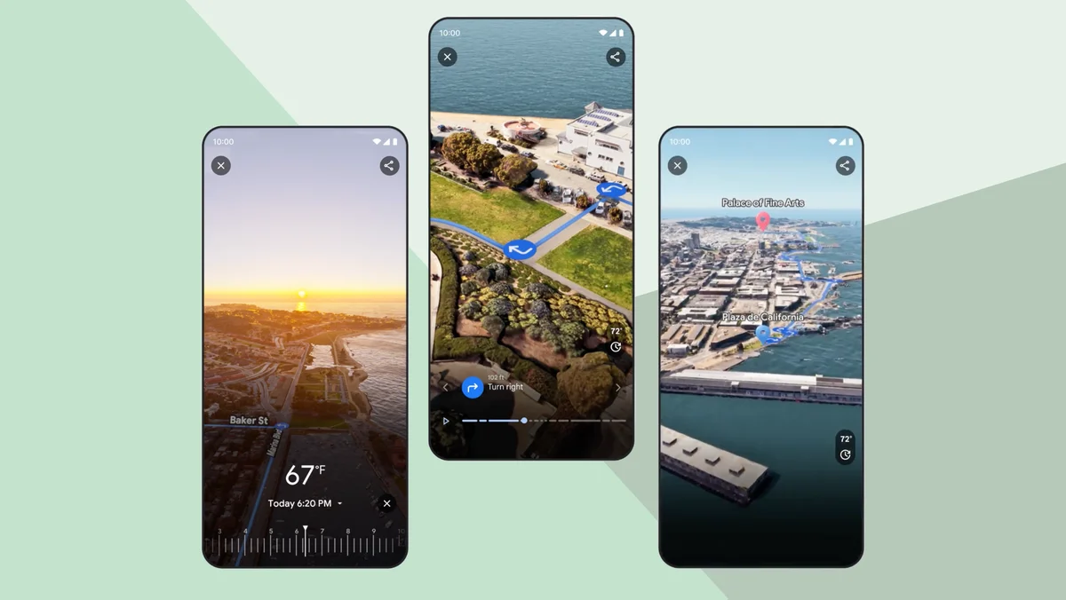
Image: Google
It is useful to obtain a sense of your path before navigating to a destination so that you can travel with confidence and avoid getting lost. Let’s assume you’re going to meet some friends in a park and you’re going to cycle there. Before you leave, you might check the weather, look to see if there are any road closures along the route, or use Street View to investigate where you can park your bike. Because of this, Google developed a feature called Immersive View for routes, which provides you with all of the information that you require for your journey.
Take a look at how AI (artificial intelligence) and images work together to bring Google Maps‘ Immersive View for routes to life.
Putting together a jigsaw puzzle of 2D imagery
First, billions of high-resolution images are gathered. These can originate from a variety of sources, including airplanes, Street View vehicles, and trekkers. The next step is to stitch the photos together, which is a lot like assembling the largest jigsaw puzzle ever.
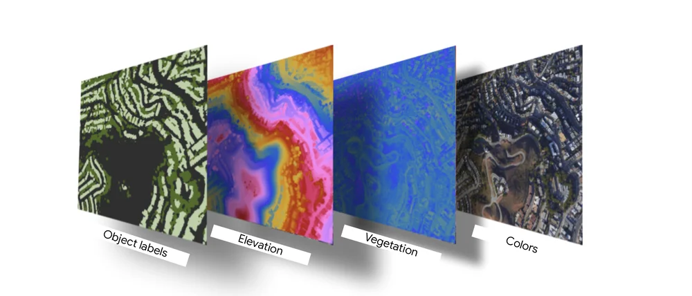
Image: Google
In principle, this sounds quite basic, but numerous factors make this process quite complex. For the roads, streets, and business names to make sense, the photos must be in sync with the Google Maps database. Our precise photogrammetry methods enable us to align images and data to within millimeters, making this a reality.
Using machine learning to extract and label helpful information
Google then employs artificial intelligence and computer vision to analyse the aligned photos and determine what is present. Google’s machine learning algorithms can read pedestrian walkways, speed limit signs, road names, addresses, business hours, and doorways in a photograph in a matter of seconds. Because these models are taught with millions of images from different parts of the world, they can quickly adapt to new settings. For instance, they understand the difference between the triangular, primarily white and red “SLOW” sign used in Japan and the diamond-shaped “SLOW” sign used in the United States.
Understanding these elements helps Google display the most helpful information in Immersive View for routes. Google Maps may now direct you directly to the front door of a building rather than simply the general area, avoiding a needless journey around the block.
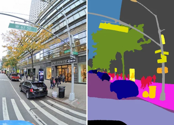
Image: Google
Transforming 2D imagery into 3D
“With all the visual elements and object labels in their designated spots, the next step involves the intricate process of constructing a 3D representation of the world. One of the most formidable challenges in this endeavor lies in accurately modeling the terrain of roads and the heights of buildings. To tackle this task, Google harnesses the power of cutting-edge aerial camera systems, akin to the sophisticated 3D cameras employed in the film industry. These camera systems consist of clusters of cameras, each oriented in slightly different directions, enabling them to capture images from multiple vantage points and acquire a precise sense of depth.
Once Google has obtained this collection of imagery, they apply advanced photogrammetry techniques to seamlessly integrate these images into the existing 2D model of the world. This transformative process elevates the flat, two-dimensional representation into a fully-fledged three-dimensional model, bringing the world to life in all its immersive glory.”
Creating a realistic, helpful route
After Google’s 3D model is complete, it will be necessary to guide how to move forward. This is the key feature that sets Immersive View for routes apart from Immersive View for destinations. Creating a realistic and useful overview of your journey path, be it a road, bike lane, or sidewalk, is one of the main problems of overlaying the route line in 3D. The problem is solved by Google, which utilises multiple methods.
Google also incorporates numerous complex camera zooms, pans, and tilts to give you a birds-eye view of your path as well as information about individual streets. When the blue route line is supposed to run under a bridge or around a tree, for example, it is obscured using a method called occlusion. Google uses a mathematical construct called a B-spline curve to generate a smooth camera path that provides a good perspective of the road, ensuring that the dynamic movement does not feel abrupt or jumpy to you. Together, these methods allow their system to rapidly determine what should be in view at each stage and consistently produce a visually appealing and simple-to-follow path in real-time.
Adding Google Maps’ trusted, real-world information
Google Maps continues to evolve by incorporating trusted, real-world information to enhance user experiences. The platform now offers a wide array of data, sourced from both users and verified contributors, ensuring the accuracy and relevance of the information. This includes up-to-date details on businesses, hours of operation, reviews, photos, and more. Additionally, user-generated content, such as photos and reviews, provides a dynamic view of locations, helping others make informed decisions.
Google Maps relies on a network of “local guides,” who actively contribute knowledge and improve data quality. The integration of real-time data like traffic conditions, transit schedules, and live location sharing makes it an indispensable tool for navigation. By continuously adding trusted, real-world information, Google Maps ensures users have access to the most comprehensive and reliable data when exploring their world.
Bringing it all together
Together, these elements use on-device and real-time cloud rendering to present your path on your phone, allowing you to see exactly where you’re headed at all times. Amsterdam, Barcelona, Dublin, Florence, Las Vegas, London, Los Angeles, Miami, New York, Paris, San Francisco, San Jose, Seattle, Tokyo, and Venice are the first to receive Immersive View for routes.
Read more tech news here to see how the latest market developments could shape your digital experience.

Words by
Shikha Rana
More News
DeepSeek vs Llama 3 vs GPT: Comparing Open Source Models
Why WWDC24 Will Be The Most Electrifying Developer Conference
Future of Computing: Microsoft’s 2024 Surface AI Event